

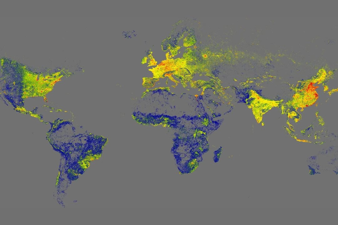

A research team at the Technical University of Munich (TUM) has successfully compiled the first high-resolution, three-dimensional map of every building on the planet. Named the GlobalBuildingAtlas, this open dataset comprises 2.75 billion building models, covering all structures captured in 2019 satellite imagery.
This extensive collection is the most comprehensive of its kind, significantly surpassing the largest previous global dataset, which contained approximately 1.7 billion buildings. The 3D models boast a resolution of 3×3 meters, making them 30 times finer than data found in comparable databases.
The project, led by Prof. Xiaoxiang Zhu, holder of the Chair of Data Science in Earth Observation at TUM, was funded by an ERC Starting Grant. The goal was to answer fundamental questions about the number and 3D nature of buildings on Earth.
Crucially, 97 percent (2.68 billion) of the structures are provided as LoD1 3D models (Level of Detail 1). These models offer a simplified representation that captures the basic shape and height of each building. Although less detailed than higher levels, this format allows for large-scale integration into computational models, providing a precise basis for volume calculations and urban structural analyses. Unlike previous mapping efforts, the GlobalBuildingAtlas includes structures from regions often excluded from global datasets, such as rural areas, Africa, and South America.
Professor Zhu states that the data provides a critical foundation for climate research and for meeting the UN Sustainable Development Goals. The detailed 3D information allows for more accurate models covering urbanisation, infrastructure, and disaster management. These models, in turn, help to improve the resilience and inclusivity of cities globally.
Professor Zhu noted that three-dimensional building information provides a much more accurate picture of urbanisation and poverty than traditional two-dimensional maps. She explained: “With 3D models, we see not only the footprint but also the volume of each building, enabling far more precise insights into living conditions.”
The map introduces a new global indicator called building volume per capita. This metric measures the total building mass relative to the population, thereby revealing social and economic disparities related to housing and infrastructure. Professor Zhu added: “This indicator supports sustainable urban development and helps cities become more inclusive and resilient.”
The open access 3D data provides a precise basis for the monitoring and planning of urban growth. This allows cities to implement targeted measures for creating more equitable living conditions. Examples include planning public facilities like schools or health centres, or additional housing in densely populated, disadvantaged neighbourhoods. The data is also considered vital for climate adaptation, improving models for CO2 emissions and energy demand, while supporting green infrastructure planning. Furthermore, the dataset strengthens disaster prevention efforts by enabling the quicker assessment of risks posed by natural events such as floods or earthquakes. The German Aerospace Center (DLR) is already examining the use of the GlobalBuildingAtlas as part of the “International Charter: Space and Major Disasters.”


![[IRHM] logo](https://irhmagazine.com/wp-content/uploads/2025/08/IRHM-AWARDS-2025-1024x683.jpg)